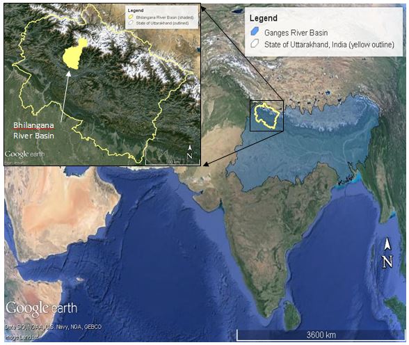
Bhilangana Basin. Imagery from Google Earth, Landsat.
Last summer, University of Arizona researchers along with our local partners scouted research sites in the Himalayan foothills of India’s Uttarakhand state. Here, we spoke with residents of villages along a tributary stream of the Ganges River Basin – a river system that supports over 650 million inhabitants and holds weighty spiritual significance for many. But in this small tributary near the Ganges headwaters, residents were concerned about the effect of newly-installed hydropower impoundments and powerhouses on the security of their water and land resources.
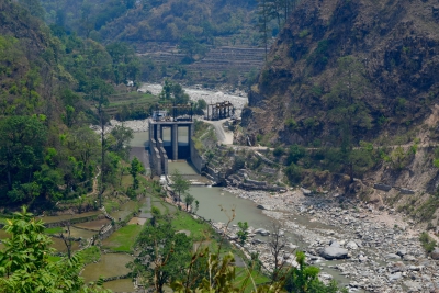
In Uttarakhand, as many as 450 new hydropower facilities are being developed rapidly and haphazardly. Installation of hydropower facilities presents a complex combination of benefits and risks for local residents. Hydropower facilities can provide local electricity, flood control and water storage for climate mitigation. However, there can be negative impacts. Road access to hydropower facilities as well as tunnel construction (dynamiting, rubble removal, etc.) is reported to increase landslides. Residents have observed decreases in flows from groundwater springs, commonly the source of drinking water in villages, which may be related to construction disturbance or climate change. Additionally, hydropower can interfere with irrigation diversions especially for the critical pre-monsoon rice-sowing season when river flows are at their lowest.
In some cases, negotiated agreements have allowed for the timely release of irrigation water. Irrigation and hydropower can co-exist, especially where user groups for both water and electricity are involved in planning. Under these complicated conditions, water security is entangled in a web of tradeoffs and complementarities between water, energy, food and livelihoods – and the nexus of these interlinked factors.
Building upon our expertise in transboundary water security in the Americas and the U.S.-Mexico border region, the University of Arizona/Udall Center team has leveraged existing contacts and the team’s research experience to expand IWSN activities in South Asia, particularly in the Himalayan region. The Himalayan region is a critical area in the assessment of South Asia’s water security. These highlands are a significant source of fresh water due to large quantities of water stored in mountain glaciers, but are also a source that is at high risk of adverse effects from climate change.
Our team is collaborating with university, NGO, and government-agency partners in Uttarakhand on a project entitled “The irrigation-hydropower nexus in the Ganges headwaters” supported by the Research Program on Water, Land and Ecosystems of CGIAR. CGIAR is a global research partnership for agricultural development led by the International Water Management Institute. Our work in Uttarakhand, along with our team’s research in Nepal, contributes to one of IWSN’s research foci, Transboundary Water Security, specifically in South Asia.
In Uttarakhand’s Himalayan foothills, we are investigating the interrelationships between water, energy and food – all of which contribute to the water security of the region. This research considers both the hydro-technical aspects of water availability and the social, political and economic conditions specific to the Himalayan foothills, the approach on which the IWSN project is founded. Here, the irrigation-hydropower nexus involves many factors such as potable water supply, irrigation water, grid electricity, hydro-electricity production, biomass, crops, and the gendered livelihoods entwined in crops and livestock.
Science Institute (Dehra Dun, India)
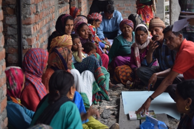
To account for this complicated set of relationships, our research focuses on both physical and social aspects of water security in the Bhilangana River Basin. The Bhilangana River Basin is less than 2,000km2 in area but already has 10 hydropower facilities. In the summer of 2015, our team, along with our partners at the People’s Science Institute in India, interviewed local residents to learn about how their water access, livelihoods and crops had changed since the hydropower facilities had been built. Most local residents make their livelihoods from crop cultivation or in other ways that depend on land and water resources. To compliment these observations, we also needed to improve our understanding of the local hydrologic regime, which was challenging because the availability of hydrologic data in Uttarakhand is limited. Most significantly, we needed an efficient, simple tool to estimate streamflows and the effects of hydrologic changes on local and regional water security.
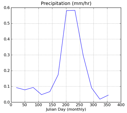
Currently, we are working to apply the WaterWorld model as a tool to evaluate the hydrologic regime for a nexus-based approach to assess water security in the Himalayan foothills. WaterWorld is a web-based tool designed to inform policy decision-making for water and land resource questions. The system was developed by Dr. Mark Mulligan and his research team at King’s College, London (Mulligan, M. (2012). WaterWorld: a self-parameterising, physically-based model for application in data-poor but problem-rich environments globally). It provides high-resolution global datasets for hydroclimatic factors, such as precipitation, air temperature and wind speed. These factors can be used to perform simple calculations to estimate the effect of changing global temperatures on precipitation, stream water levels and glacial melt. Compared to other modeling and calculation tools, WaterWorld provides the unique ability to make estimates for large areas (for instance, on a national scale) and also provides the ability to evaluate almost any location in the world. The global data provided can also be supplemented with local measurements, if available, to better represent local conditions. Although many existing applications of WaterWorld have been on a national or large-basin scale, our team is investigating the application of this tool in a small watershed using local data and field observations together with the global data sets.
policy support system (Mulligan, 2012).
Our preliminary results from WaterWorld show pronounced seasonal variations in streamflow on the Bhilangana River and its tributaries. A dramatic peak in precipitation and streamflow is suggested to occur on average in July or August, with stream flows approximately ten times the typical flow during the rest of the year. Next, we will incorporate local and field-observed data to improve this estimate of precipitation and evaluate changes in stream flows.
We will then be able to evaluate the potential effect of climate change on local water resources. Changes in the timing or amount of seasonal precipitation could affect the potential of the newly installed hydropower facilities to produce the projected amounts of energy. Changes in stream levels due to diversions for hydropower facilities or climate change could significantly impact local residents’ access to water for irrigation – affecting both their ability to produce food and their ability to maintain their land-based livelihoods. High rates of rainfall can contribute to the likelihood of landslides and flooding. These are all important factors contributing to the region’s overall water security.
We plan to visit the Bhilangana River Basin again in the summer of 2016 to conduct mapping, streamflow measurements, and an assessment of changes in local residents’ water access. Preliminary results from WaterWorld models will help guide our field efforts and be useful for eliciting local residents’ observations of changes to streamflow and water availability and their impressions of the potential impact of future changes in water availability to contribute to an improved understanding of both local and regional water security in the Himalayan foothills.