(Translated by Adriana Zuniga)
 Remote sensing has become a widely utilised tool in environmental sciences, particularly hydrological studies. The scientific community has developed remote sensing applications for each aspect of the hydrologic cycle including precipitation, flood monitoring, evapotranspiration, groundwater, and soil moisture. However, the potential use of remote sensing for the monitoring of extreme hydrologic events including floods, drought, and water governance has not been completely explored. There is a need to build capacity in order to increase the use of these products, especially with regards to water resources management.
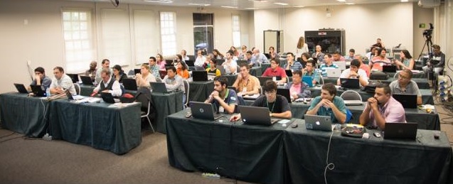
For this purpose, the United Nations Educational, Scientific, and Cultural Organization – International Hydrological Programme (UNESCO-IHP) in collaboration with the Water Center for Arid and Semiarid Areas of Latin America and the Caribbean (CAZALC), and the Flanders UNESCO Science Trust (UNESCO FUST) organised an international workshop on ‘Remote sensing applications to support water resource management in Latin America and the Caribbean.’ The workshop took place from 13-20 July 2016 in Foz do Iguaçu, which is a Brazilian city located on the border between Brazil, Argentina and Paraguay, right on the convergence of the Iguaçu and Parana Rivers. This workshop took place in the International Hydroinformatic Center (CIH), which is a Category II UNESCO Centre, and is part of Itaipu Binational – the second largest hydroelectric plant in the world. Workshop activities were held in the Itaipu Technological Park (PTI), which is located close to the buildings that were once the residences of the builders of the Itaipu Dam in the 1980s.
The purpose of this workshop was to train researchers, water professionals, water resources managers, and personnel working in water agencies and governmental institutions in the state-of-the-art use of remote sensing technology for water resource management. The workshop involved a series of examples of practical applications that can be transferred and applied to other parts of the world.
This workshop is part of the activities of the research project “Manejo de los recursos hídricos en regions áridas y semi-áridas de América Latina y el Caribe” (Water resources management in arid and semi-arid regions of Latin America and the Caribbean, MWAR-LAC). Participants of the workshop came from Brazil, Argentina, Paraguay, Uruguay, Bolivia, Venezuela, Chile, Costa Rica, Colombia, Nicaragua, Cuba, Mexico, Belize, Guatemala, Peru, United States, Belgium, and the UK.
The topics covered included the identification of the different components of the water cycle using remote sensing, with an emphasis on freshwater and risk management of water-related disasters. During the workshop, participants learned about the best tools to use for water resources management and some of the portals that provide data access including free data from NASA, and real-time data from the European Organisation for the Exploitation of Meteorological Satellites (EUMETSAT). Examples on the use of these tools were also shared during the workshop and include the use of remote sensing for the management of drylands in Brazil, estimation of precipitation, and flood predictions models developed by scientists from Princeton University.
 One of the most popular topics of this workshop was the use of LIDAR data (light detection and ranging) because this data can be used during daytime or nighttime, regardless of the meteorological conditions including cloud cover. We learned about the wide range of uses of LIDAR data that record features such as topography, wetlands, soil moisture, oil spills, and vegetation cover. Furthermore, this workshop also included sessions on evapotranspiration and the complex way to measure this natural process. Another topic addressed in this workshop included remote sensing applications to measure snow cover and snow water equivalence. This is very important for the monitoring of the climate and water resources management. The workshop also hosted talks about drought monitoring models (e.g., SPIRITS) that can calculate long-term time series of drought and measure anomalies using different statistical analyses. Finally, we also examined remote sensing applications to measure soil moisture and its relationship with agricultural production, drought-prone areas, flood-prone areas, and landslides. Some research projects on soil moisture look at areas of risk for vector-borne diseases, including malaria and yellow fever.
My colleague Wilmer Moncada and I are researchers who have been studying hydrological basins in Peru, and in this workshop we presented our research study on the Cachi and Chancay/Lambayeque Basins. This project is part of the scientific program Agua-Andes (Water-Andes), which in turn is part of the Cento de Competencias de Agua (Water Center of Competence). In this project we are using remote sensing to identify wetlands in the high areas of the Andes Mountains because these ecosystems play a critical role in water resources management of the region.
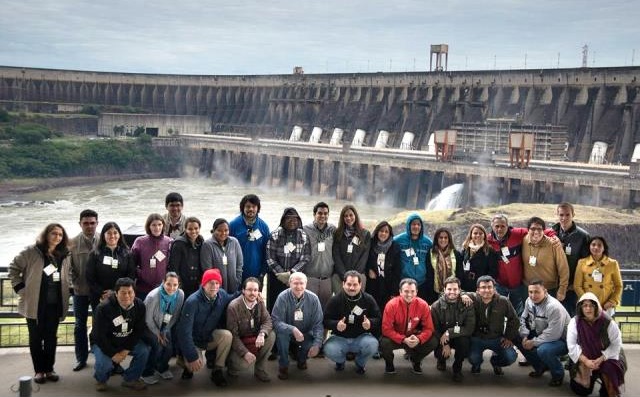
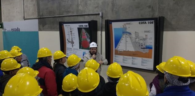 The workshop included a fieldtrip to Itaipu Binational. This dam is located in the border between Brazil and Paraguay on the Parana River. It was very interesting to see that the border between the two countries lies exactly in the middle of the main operation rooms of the dam, where employees from the two countries work together.
In the course of eight days, we were exposed to new remote sensing technologies, a wide range of applications for these tools, and portals where we can access free data in real time. Most importantly, we met colleagues who share the same interests and challenges across Latin America and other countries and with whom we can collaborate in the future.
Note from the author: We are grateful to the International Water Security Network (IWSN) and UNESCO for their support that made possible our participation in this workshop. We are also grateful to Itaipu Binational for hosting the workshop and for letting us use their facilities.
Another report on this workshop can be found here.